The trail that no one talks about
At least that’s how it felt when I tried to gather last-minute information about the Alta Via 8 before my trip to the Dolomites this September. There are a total of ten high mountain paths – the Alta Via delle Dolomiti – that lead through the Italian Dolomites. The most popular ones are without question the Alta Via 1 and 2. The fact that the internet is flooded with blog posts about those might be one of the reasons why information about the others are so hard to find. That’s about to change, hiker friend! Here’s everything you need to know about hiking the Alta Via 8.
Quick & dirty: The Alta Via 8
The Alta Via 8 starts in Bressanone, one of the oldest towns in Tyrol, and leads through the Nature Parks Puez-Odle, Sciliar-Catinaccio and Monte Corno over 152 km to the southernmost community in South Tyrol, Salorno.
| Length: | 152 km (95 mi) |
| Country: | Italy |
| Start: | Bressanone |
| Finish: | Salorno |
| Season: | Mid-June to late September |

What to expect
- a scenery that makes every hiker’s heart beat faster
- enchanted valleys and rocky mountain passes
- magnificent views over the clouds
- steep climbs and descents, that will make your knees curse you
- countless opportunities to stop for a bite to eat and stuff your face with apple strudel and dumplings
- a cosy bed in a mountain hut or right under the night sky*
* Camping is generally prohibited in the entire Dolomites, but not impossible. More on this at the end of this post!
How to get there
South Tyrol can be easily reached by train and bus from the neighboring countries. When you travel from further away, your best bet is probably to fly to either Innsbruck (AUT), Verona (IT), or Munich (GER) and then travel on to Bressanone by train. Check out your options on Rome2Rio. In Bressanone I spent one night at the Youth Hostel, which makes the perfect homebase for exploring the city before continuing on to the start of the trail.

The actual starting point of the Alta Via 8 is on the Plose massif. St. Andrä in Monte can be reached by bus in just 20 minutes from Bressanone. From there, you can either take the cable car up (14.90 €) or walk (approx. 2 hours of steep uphill) to the starting point of the Alta Via.
Trail conditions
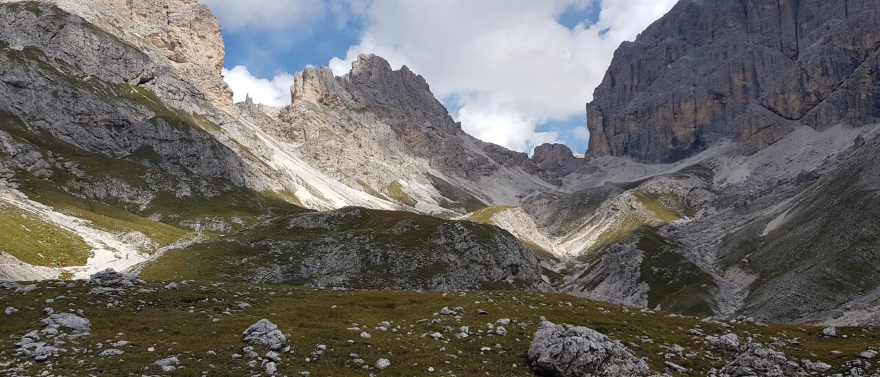
Even though the trail is described as one of the easier Alta Vias, it’s still a high route! The trail goes up and over mountain passes on a daily and I gotta admit – I underestimated the elevation on this trail big time. My hiker legs from the PCT were long gone and every steep climb was a little challange in itself for me. Once up there, you will be rewarded with the most breathtaking mountain panoramas, though.

In the beginning the way still leads over soft forest paths and dirt trails, but becomes increasingly rugged until the Brogles hut. Shortly after Ortisei, the path leads over the Alpe di Siusi to the Sciliar-Rosengarten Nature Park, an absolute highlight of the hike.

The only official via ferrata passage on the trail can be avoided, if wanted, via an alternative starting from the Vajolet hut. As a bloody beginner in climbing, my heart was pumping even on the easy Santerpass climb (I/II), which was perhaps due to the thick layer of fog that completely hid the route when we started going down. Some type 2 fun!


Someone might have had a little panic attack at that spot
However, we were much more challenged at a different section of the track. The last 2 km up to the Latemar summit lead over a very narrow, unsecured path along the mountainside and demanded absolute surefootedness. Definitely not recommended in bad weather conditions or with a large backpack. The narrow (climbing) path along the slope caught us a bit by surprise, as it was not mentioned as such in any of the information gathered before the hike. As a matter of fact, we descended just before the summit, because we were not comfortable with the climbing a especially sketchy section with our backpacks on and several people had already ahead of us, turned around for similar reasons.

If you want to tackle the climb up Latemar try to travel as light as possible and keep an eye on the weather conditions in the mountains then you should be just fine. In our case: Better safe than sorry. Even though it was a frustrating experience to backtrack, we jumped back on trail at the next possible point. From there it is a steady up and down to Salorno. Apart from the spots mentioned, the path is generally well maintained and, despite the many elevation changes, easy to walk on.
But how long does it take?
You’ll find many different opinions on how long it takes to hike the Alta Via online – from 12 to at least 10 days to a proud 18 stages. Let’s be real: Experience, physical fitness and personal preferences all play a part in how long it takes to complete a trail. While some peeps like to reach their destination for the day just after noon and enjoy the rest of the day at the mountain hut, nothing makes me happier than falling into my tent in the evening – exhausted and with heavy legs.

We walked the route in a total of eight days in September. However, since the ride home already arranged and still a few days away and we didn’t want to spend extra money for lodging in town, we dilly-dallied around a lot during the last days and spent long breaks at the alpine huts sipping cold drinks and playing cards. For ambitious hikers, however, the trail is certainly still manageable to do in 6-7 days. The great thing about the Alta Via 8: Thanks to a large network of accommodation, the stages can be arranged to suit your individual needs.

How not to get lost
Phew, navigation on the Alta Via 8 is a thing of its own. Unfortunately, the trail is not continuously marked on site. In fact, the only signs that have marked a long-distance trail were those of the Alta Via 2, which shares the first couple of stages with the Alta Via 8. The trek must therefore be understood as a series of several local hiking trails.
My recommendation for navigation on the trail is the app Komoot. The GPS data can be viewed fir free and for small money you can download the handy offline maps. The only drawback: Many huts are marked as buildings, but without their names.
If you don’t like to stare at your phone all the time, the easiest way to find your way around is to follow the sign-posted huts. Since I couldn’t find a complete list of huts the trail passes before I started, I created my own overview (with the original names). From north to south you will pass the following waypoints:
| km | Waypoint | Note |
| 0 | Plose | |
| 2 | Plosehütte | |
| Edelweißhütte | off-trail | |
| 15 | Schlüterhütte | |
| Gampen-Alm | ||
| 20 | Glatsch-Alm | off-trail |
| 24 | Brogleshütte | direct descent to Ortisei possible |
| Panascharte | closed due to landslide (09/2020) | |
| 27 | Troierhütte | |
| 30 | Regensburgerhütte | |
| 39 | Ortisei | grocery store (Despar) |
| 42 | Seiser Alm | option to take the cable car |
| 50 | Saltnerhütte | shortly afterwards: ascent of death |
| 54 | Schlernhaus | |
| 59 | Tierser Alpl-Hütte | |
| Rifugio Passo Principe | ||
| 64 | Vajolethütte | quite touristy, but: A VEGAN MENU! |
| Gartlhütte | ||
| 66 | Santerpasshütte | epic location |
| Santerpass | via feretta | |
| 68 | Kölnerhütte | |
| 72 | Rifugio Paolina | |
| 74 | Karerpass | mini market |
| 78 | Latemarscharte | this is the sketchy part |
| 80 | Latemar-Biwak | |
| 84 | Rifugio Torre di Pisa | |
| 86 | Passo Feudo | |
| 93 | Lavazépass | restaurant and guesthouse |
| 94 | Malga Verena | |
| Jochgrimm | ||
| 98 | Gurdin-Alm | |
| 111 | Kaltenbrunn | mini market, gas station |
| 114 | Trodena | small grocery store (Despar) |
| 119 | Krabes-Alm | we loved it here! |
| 124 | Horn-Alm | |
| 129 | Gfrill | restaurant and guesthouse |
| 135 | Rifugio Potzmauer | lovely location in the woods |
| 143 | Lago Santo | you can take a dip in the water here! |
| 146 | Rifugio Sauch | |
| 152 | Salurn |

What to eat and where to sleep
If you’re craving dumplings or apple strudel after one of the long ascents, it is usually not far to one of the countless mountain huts. In addition to the huts that only serve delicous food, there are numerous places overnight stays as well. A bed in a dorm with breakfast usually costs between 30-50 €. More, if you choose to get a private room to escape the snoring and an extra 20 for dinner and drinks. If you can afford it, this is certainly the most pleasant way to walk the Alta Via 8, but it’s not exactly budget-friendly.

Low-budget, baby!
We also treated ourselves to one, two, three occasional aperitifs at the huts and I just couldn’t resist the vegan options in the Vajolet valley. But apart from that we did it the low-budget way. We bought snacks and dinner for 2-3 days in Ortisei, at Lake Carezza and in Trodena. With the exception of one night in the Schlernhaus and in the Kölnerhütte and one night in the Bed & Breakfast in San Lugano near Trodena, we spent the nights in our tents. Despite wind and weather. Because what’s better than to gaze at the Milky Way during your midnight piss?

Although wild camping is not allowed in the Nature Parks and the rules for bivouacing are confusing, camping on private land on the other hand is allowed with the permission of the owner. Everyone we asked if there might be a place nearby where we could pitch our tents for one night was happy to offer us a spot on their farmland. If you should end up having to stealth camp know that we didn’t encounter a single park ranger along the whole trail. Just don’t forget the golden rule of backpacking: Leave No Trace. And enjoy the heck out of the Dolomites.
